Riserva Naturale
Grotta di S. Angelo Muxaro
The “Cave of Sant’Angelo Muxaro” Nature Reserve is located in the inland of the Free Municipal Consortium of Agrigento, at the foot of the hill of Sant’Angelo Muxaro, a gypsum tabular elevation about 350 meters above sea level, where the homonymous town stands.
The area of the Reserve extends over about 21 hectares and is divided in two zones depending on the environmental features and the different use purposes:
- Zone A, the surface area, with the main entrance of the cave, and the sinkhole located immediately to the west (the former known locally as “Grotta Ciavuli” or “Grutta Ciavuli”, and the latter as “Infantino sinkhole”); both are located along the southern slope of the hill of Sant’Angelo Muxaro. Included in zone A are also the underground paths that start from the two cavities, for a total length of about 1.7 Km;
- Zone B includes a pre-reserve area that protects part of the water catchment basins that feed the two karst cavities: these are two blind valleys hollowed out from the clays below the evaporitic deposits.
Since 2015 the karst system, only partially protected by the reserve, has been included, as a multiple geosite named “Karst System of Sant’Angelo Muxaro”, among the Geosites established by the Sicilian Regional Government. Besides the above mentioned two cavities, also the resurgence of the karst system has been put under protection. This is a cavity located at the foot of the north-west side of the hill, from which underground water, flows into the Vallone del Ponte (Bridge Valley), a tributary of the Platani River.
R.N. Sant’Angelo Muxaro Cave
Via Messina, 1 – 92020
Sant’Angelo Muxaro (AG)
tel. 0922 919669 – 320 6580990
R.N. Grotta di S. Angelo Muxaro
Geology
The landscape of Sant’Angelo Muxaro is characterized by rises consisting of sequences of evaporitic rocks (formed by evaporation of sea water and the following precipitation of salts dissolved in it) deposited in the Messinian age, about six million years ago, in coincidence with the isolation of the Mediterranean basin. These sediments are part of the gypsum-sulphur series, widely spread in the South-West of Sicily. The evaporitic deposits are essentially made up of limestone, gypsum and various kinds of salts.
The general morphological structure of the region shows a great variability due to the presence of isolated ridges and reliefs, made predominantly of gypsum, with altitudes ranging from 200 m to 500 m above sea level, rising from the clayey-marl substrate, with steep escarpments affected by various land-falls.
The evaporitic deposits of the area consist mainly of gypsum crystals of different shapes and sizes: selenite, gypsum-alabaster, gypsum-“balatino”, gypsum sericolite, gypsum-arenite. Salt outcrops are instead present to the north of the town, along the Platani River, whose waters are in fact brackish.
Gypsum rocks are soluble in water. Over time this has caused the formation of a typical karst landscape with medium and large forms, such as sinkholes, blind valleys, etc., and of smaller extensions such as different types of karren.
The main river is the Platani, which flows north of Sant’Angelo Muxaro in an east-west direction. Tributaries of the Platani River are the Gracella Valley (also known as Grovello Stream, which includes Margi Paolino Valley and Ponte Valley) and the Porcospino Valley, located respectively to the west and to the east of the town. The tributary watercourse of the Gracella valley, which feeds the Sant’Angelo Muxaro Cave, flows underground at the foot of the gypsum hill on which the town stands. Water is absorbed by sinkholes present on the side of the gypsum slope, and surfaces from the resurgence of the Ciavuli Cave. After a short distance the watercourse flows into the Ponte Valley (the name derives from the natural bridge – a typical karst construction – present along the riverbed, evidence of ancient sinkholes).


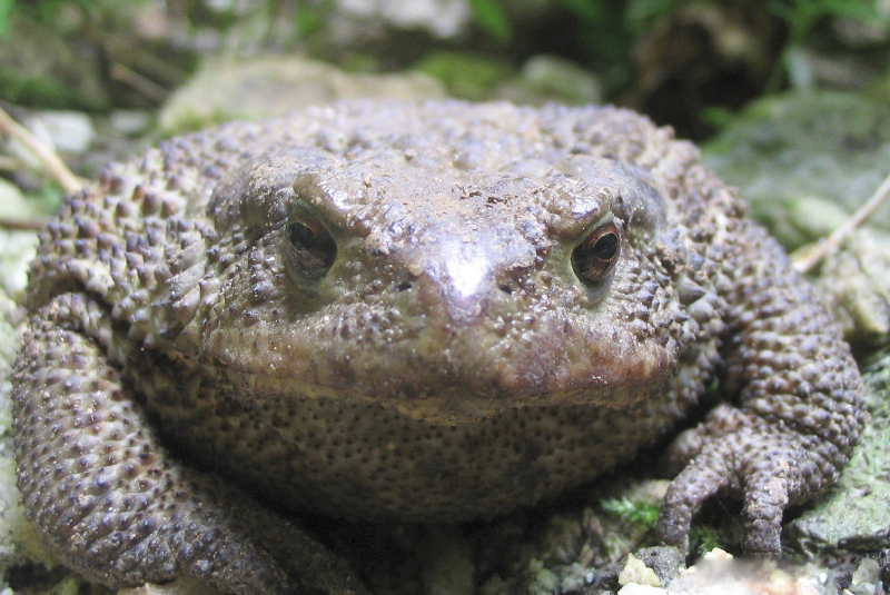
The Cave
The Ciavuli cavThe major protected cave is locally called “Ciavuli”.
It derives from the Sicilian name for the jackdaw, a bird in the craw family that is constantly present in the cavity.
The cave is part of a karst system, about 1,700 m long, formed by surface waters that flow from the blind valleys into the two sinkholes, and then, after flowing underground, emerge from the resurgence.
Waters disappear underground at an altitude of approximately 173 meters, and spring up at an altitude of about 126 meters.
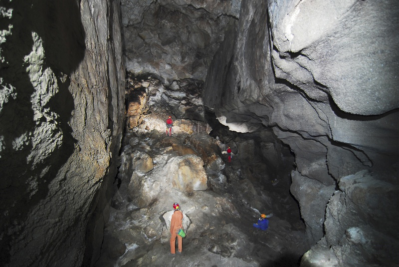
The cave is divided in two branches: one is active and can be reached by descending vertically, for a stretch of about 10 m, through an area characterized by large blocks of gypsum rock that have detached from the vault. The second branch is inactive – both at the beginning and final sections – and is the best known part of the protected site. The access is via a rolling-plain path through the large entrance hall, lit up by a large opening formed by the collapsing of the vault.
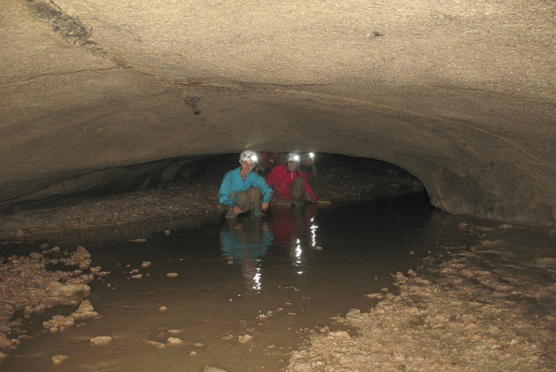
Proceeding along the active branch, about 170 m. long where currently water from the outside is channeled, one enters into an environment where the stream forms suggestive little waterfalls, and then flows into a small siphoning pool, a few tens of square meters wide, with progressively reduced lenticular cross-sections. Along the tunnel, often characterized by mud deposits, splendid crystal formations are visible, as well as a series of karstification features in evaporitic rocks. Such features include an interesting and rare gypsum column; a spindle-shaped surface concreted with stalactites and a hemispherical dome a few meters in diameter and about 40 cm deep.
The inactive branch is accessible through two overlapping passages, located at the end of the large cave. The first section, which leads into a large collapse hall, is characterized by a meandering passage with an eight-shaped cross- section, probably caused by the fusion of overlying galleries. As for largeness, the collapse room is second only to the cave entrance. From this chamber, through three alternative routes, it is possible to reach again the actual water stream (the two active segments of the cavity are separated by a siphon ). In this part the tunnel has a circular section and an average height of 2 m. The following section develops through a gorge tunnel, where various collapses occurred and there are evident alluvial clay deposits. This branch goes on for about 80 m, overlapping the lower active tunnel, to which it connects, among fallen blocks, in four sectors. Moving on further, the trail passes by areas characterized by large mud accumulations, then it reaches two not very tall lamination layers, after which the tunnel returns to be high enough to stand upright. Along the way, besides viewing splendid gypsum crystals and suggestive sinuous shapes, there are interesting supply chimneys and small collapse-halls. The water that flows down the river, after passing through a narrow, tall and meandering tunnel, merges into a siphoning pool, located in a small chamber on the western side of the main gallery, characterized by interesting layers of selenite.
The final section, beyond the chamber where the siphoning pool is located, is the non-active portion of the cave, which lies at a higher level than the above mentioned chamber, and which develops towards the northern side of the gypsum hill. This last branch , at the beginning consists of fairly wide rooms where large deposits made mostly of clay, that have created paragenetic formations, are present. The final section gradually shrinks until it becomes inaccessible, stretching up to a few meters from the surface, just north of the actual the karst system resurgence.


Flora
The reserve is part of a vast area characterized by the presence of various habitats of naturalistic interest such as: the rock and freshwater environments, and the natural and semi-natural herbaceous and shrub formations. The perennial and annual prairie formations, rich in rare species, and the rock vegetation, characterized by numerous succulents of the Sedum genus, are well represented in the protected area. There are also some garrigue patches covered in shrubs, hosting many plant species of great scientific and conservational interest (including several bulbous plants).
Pre-forest and forest flora and vegetation
Thermophilic sparse scrub vegetation has been found characterized by the presence of Euphorbia dendroides, Pistacia lentiscus, Phlomis fruticosa, Olea europaea var. sylvestris, and nuclei of forest vegetation with Quercus virgiliana, Arbutus unedo, Poa trivialis subsp. sylvicola, Asparagus acutifolius, Rubia peregrina, etc. In particular, the scattered groups of “Castagnara” Oak (Quercus virgiliana) present in Mizzaro district constitute a very important evidence of the original local forest vegetation. Both the sparse scrubs and the nuclei of forest vegetation, often extremely degraded and fragmented due to the frequent fires, are in some cases replaced by garrigue vegetation, such as Cistus salviifolius and C. creticus, Coridothymus capitatus, or by Ampelodesma mauritanica prairies.

Flora and gypsum-rock vegetation
Aspects of rock vegetation, of great scientific-conservation interest, have been found in rocky and semi-rocky areas, with very interesting species, often rare both locally and nationwide, such as Diplotaxis crassifolia, S. ochroleucum, Brassica cfr. rupestris, etc.

Flora and halophyte vegetation of the badlands
The badlands vegetation of the Barone district, to the south of the town, deserves a particular mention. In this area grows a population, one of the few known on the island, of Limonium calcarae a species endemic to Sicily, the second to be found in the Agrigento area besides the one found recently in San Biagio Platani.

Flora and hygro-hydrophilic vegetation
Interesting aspects of hygrophilous vegetation are found at some impluvia outside the protected area, in particular in the area of the Ponte Valley. These are stretches of Riparian vegetation with Salix pedicellata, Tamarix africana, Populus nigra and P. alba. These residual aspects deserve adequate protection for the beneficial role played on the overall quality of the watercourse, as well as for food availability and shelter provided to various birds and for their local and regional rarity.

Fauna
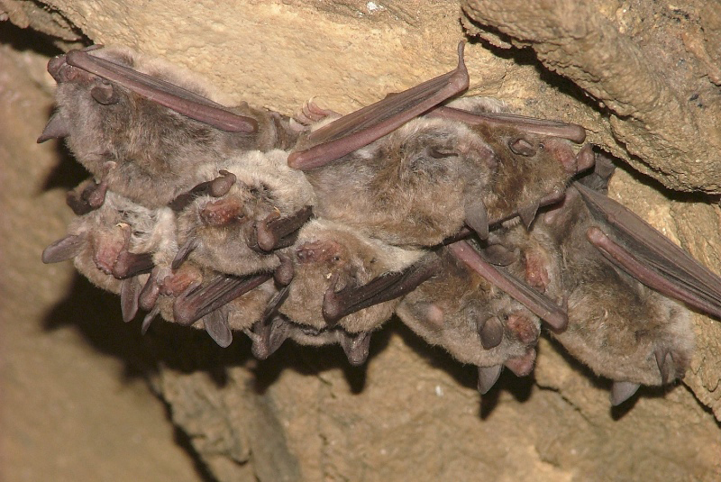
Although caves may seem to be inhospitable habitats, they host a rich and diverse fauna which, in some cases has developed an extraordinary capability to adapt to the underground environment. Regular cave dwellers are the bats, which, although not relegated there, have found in the underground environments ideal microclimatic conditions for wintering, with low and constant temperatures and high air humidity. Many species of these useful insect-eating mammals are now endangered and therefore strictly protected by Community directives.
Research carried out in the reserve has highlighted a considerable faunal interest in the Gracella Valley, in particular in the area called Ponte Valley. The importance of the site is linked to the high number and high conservation value of the species present, which nowadays are considered faunal emergencies or critical issues.
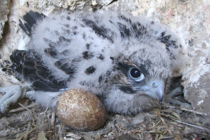
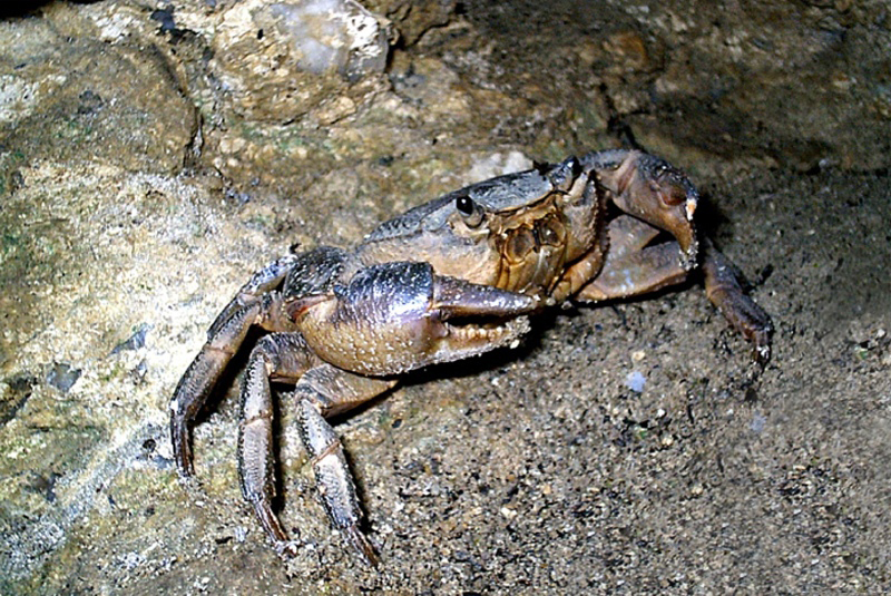
Among the species or populations that require special protection, along the Grovello Stream, is the Sicilian pond turtle, endemic to Sicily and particularly sensitive due to the delicate balance of the freshwater habitat. Other threatened species are the river crab, widely spread along the Ponte Valley and in the resurgence of the Sant’Angelo Muxaro Cave, is now rare in Sicilian rivers; the Sicilian rock partridge, a species whose population decrease is unfortunately very evident, and which requires proper hunting regulations in Sicily; the lanner falcon, that breeds on small rocky walls above the meadows, its nesting sites need to be carefully monitored in order to avoid illegal removals and disturbance actions.
Finally, the Ciavuli Cave and the various natural cavities present are the roosting and nursing sites for different species of bats; therefore this area deserves to be particularly protected, considering the high sensitivity of this species of mammals.
The Area
Among the areas of greatest naturalistic interest in the territory of Sant’Angelo Muxaro, the Ponte Valley is certainly worth mentioning. It is a tributary of the River Platani and, like the “Ciavuli Cave”, has a remarkable interest for the study of past and present water circulation and speleogenesis in gypsum rocks. The Ponte Valley is one of the sites where many karst epigeal macro- and micro-forms as well as large hypogeal configurations are concentrated. Along the Valley are present various karst macro-forms such as: gorges, caves, sinkholes, resurgences and hydrogeological tunnels, which determine an alternation of underground and sub-aerial sections of the river. The karst system is known as “Grotte d’Acqua” (literally “Water Caves”) and has been a destination for scholars since the past centuries. Of particular interest is the study conducted by Marinelli in 1899, in which the results of an excursion carried out in the area of Sant’Angelo Muxaro and Santa Elisabetta are illustrated through an accurate description of the site morphologies completed with a map.
Also the faunal and vegetation aspects are important, such as the hygrophilous vegetation that can be observed in the main valley and along some secondary valleys. Many of these natural habitats of community interest are included among those listed in the annexes of the Habitat Directive 92/43 EEC.
The Managing Body has included these areas in an expansion project of the reserve submitted in 2007 to the Former Regional Province of Agrigento and in 2015 to the Regional Territory and Environment Department of the Sicilian Region.
Due to the amount and richness of the archaeological finds, copiously spread throughout the area of Sant’Angelo Muxaro and dating back to different periods, many scholars believe that the site was inhabited by the Sicans, a local population who settled in ancient times over much of the island though, after the arrival of the Sicels, remained only in the south-central region.
Sant’Angelo Muxaro was established as an agricultural village belonging to the fief of the Chiaramonte family, near the Saracen fortress on Mount Castello. The village was entrusted by King Martino to Raimondo Montecateno; later it became a fief of the Pignatelli Dukes of Monteleone family. Around the 1500s, the inhabitants moved to the nearby hill, simultaneously with the arrival of a group of Greek-Albanian refugees, giving life to the actual town.
The village, which dominates the central Platani Valley, has an irregular grid street plan with the large Umberto I square framed by some partially remodeled noble palaces. The main sacred monuments include the Church of Itria, where historical-religious links with the Albanians can be traced, and the Matrice, with a basilica floor plan (a central nave and two side aisles), that hosts an interesting “Cross” from 1700, made of wood coated with silver lamina.
Worth to be mentioned are the Feast of Sant’Angelo Martire patron saint of the town (August 16) and the Ricotta cheese Festival (January 6).
Numerous tholos tombs, some of the largest ones in Sicily, cut into the rock of the Sant’Angelo Muxaro hill and in the surrounding areas, have been found. The architecture of these tholoi shows an evident influence of the Mycenaean culture. Besides their amazing beauty, the protohistoric necropolises have preserved greatly valuable objects, such as engraved gold rings, decorated amphorae and pitchers made of earthenware, bronze jewels, now preserved in the archaeological museums of Agrigento, Palermo and Syracuse. The most important object found in this area is a beautiful rare gold plate, preserved in the British Museum in London.
It has been suggested that in this area was the mythical Kamicos, the town of the Sican king Kokalos. The story of Kokalos is intertwined with the legend of the labyrinth built by Daedalus and the fate of its maker. The latter, to escape the anger of King Minos, having fostered the love of the Cretan queen with the Minotaur, fled from Crete with his son Icarus and found shelter in Kamicos. King Kokalos was in great discomfort. He couldn’t betray his guest, but he feared the power of the Cretan army. Thus he fooled King Minos: pretending to surrender Daedalus, he invited the foreign king at his house, where, during his bath, the daughters killed him.
